


The peninsula showed a decrease in 56% with respect to the quarter of the previous year, This was revealed in the report issued by IDEAM and USAID.
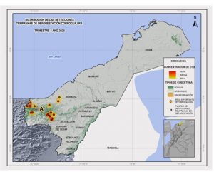 Dibulla and Riohacha, the municipalities in the department of La Guajira where early detections of deforestation occurred due to the expansion of agricultural borders in prohibited areas, This was revealed in the report on early detections of changes in key ecosystems of the Caribbean and the Colombian Orinoquia issued by IDEAM and USAID.
In the District of Riohacha, 11 deforestation points located in the Sierra Nevada de Santa Marta in the Kogui - Malayo reservation- Arhuaco and in the village of Tigreras, being the main cause burns that affect the natural forest.
Meanwhile, in Dibulla the 9 The points found are located in the Sierra Nevada de Santa Marta in the Kogui - Malayo - Arhuaco reservation in the Palomino district, also in Río Ancho and Punta de los Remedios.
The hydrographic subzones involved in the deforestation processes correspond to Río Ancho, Ranchería River and Tapias River. However, the department of La Guajira presented a decrease in 56% deforestation compared to the third quarter of the previous year.
The Regional Autonomous Corporation of La Guajira - Corpoguajira will continue to exercise control and surveillance of natural resources and will continue to bet on the conservation and care of biodiversity.
Leave a reply
I am sorry, you should be connected to post a comment.